Kheerganga Trek (Kasol) Guide: The "Hippie Trail" to Hot Springs
📍The Mighty Himalayas (North India)
The Summit Summary
- Location: Himachal Pradesh (Parvati Valley, Kullu District).
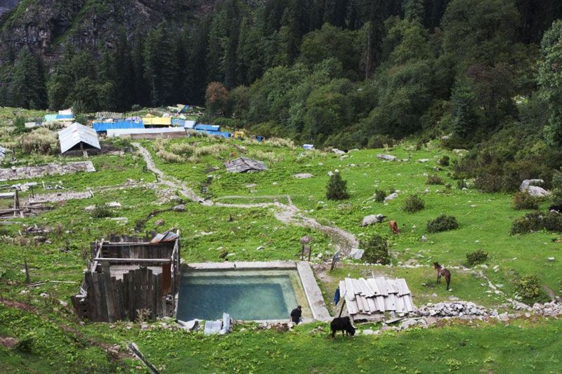
- The Vibe: A "Backpacker's pilgrimage." It is less about the summit and more about the culture. You walk through deep pine forests, pass by waterfalls, and end at a natural hot water spring (Parvati Kund) at 9,600 ft, surrounded by snow-capped peaks and vibrant cafes.
- Difficulty: Easy to Moderate. The distance is manageable, but some sections are steep and muddy.
- Duration & Variants: 1-2 Days (Standard Itinerary). 24 km Total Distance (Round Trip).
- TrippinAI Recommended Slot: April to June (Pleasant weather) or September to October (Post-monsoon clarity).
- The TrippinAI Rating: "At TrippinAI, we rate this trek a 3/10 on endurance (manageable for fit beginners, but the humidity in the forest can be draining)."
The Climb: What to Expect
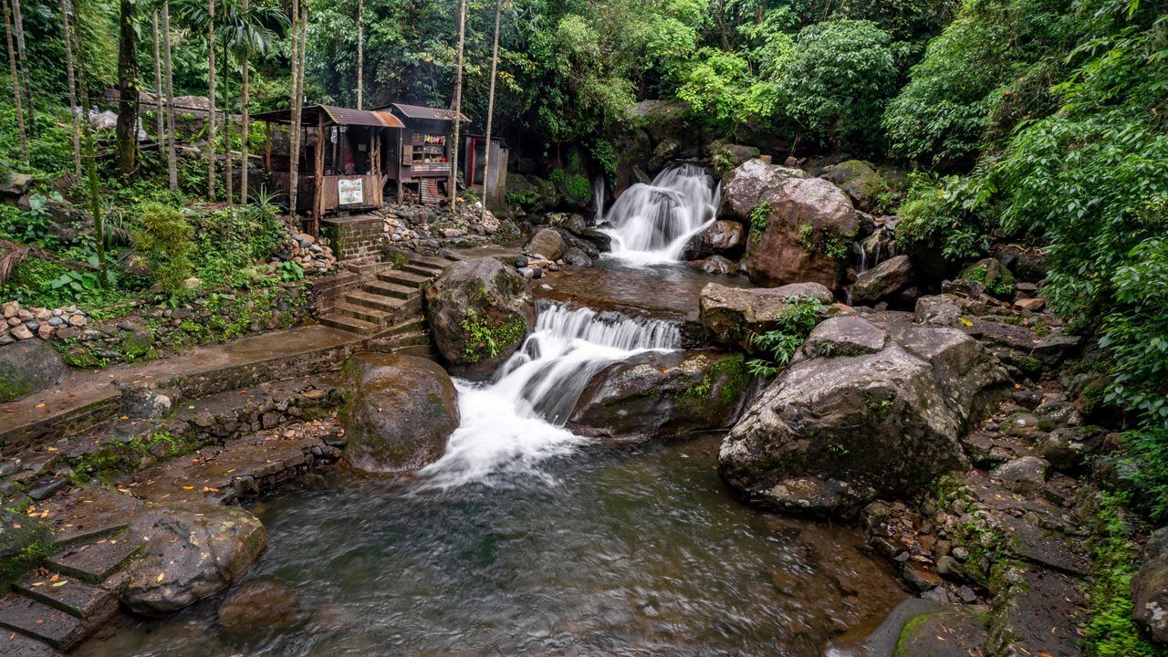
The Reality Check: The trek to Kheerganga is a journey through the heart of the Parvati Valley. It starts at Barshaini, where the Parvati and Tosh rivers meet. You have two route options: the forest route (via Kalga) or the village route (via Nakthan). Both converge into a trail shaded by massive pine trees. The sound of the river is your constant companion. As you climb, you pass the Rudra Nag waterfall—a serpent-shaped cascade. The final ascent opens up into the Kheerganga meadow, a plateau dotted with tents and cafes. The climax is dipping your tired body into the sulfur-rich hot springs while gazing at the glaciers of the Spiti border.
Why It's Famous & What Trekkers Say
The Fame Check:
- The "Shiva" Connection: Legend says Lord Shiva meditated here for thousands of years. The hot spring (Kheerganga) is believed to be "Kheer" (rice pudding) created by Shiva for his son Kartikeya, which later turned into water in Kalyug.
- The "Kasol" Vibe: It is the quintessential extension of the Kasol trip, famous for its relaxed, cafe-culture atmosphere at the top.
The Social Pulse:
- The Good (What Trekkers Love): The Hot Springs! There is nothing like a hot bath at 9,600 ft. The cafes serving Nutella pancakes and Israeli food are a huge hit.
- The Bad (What Trekkers Hate): The mud. In the rainy season, the trail becomes a slush fest. The crowds on long weekends can be overwhelming, ruining the peace.
The Trail: Milestones & Route Map
The Route Breakdown:
- Barshaini: Start Point (6,600 ft). The Highlight: The dam site. This is where the road ends and the trail begins.
- Nakthan Village: En-route (Village Route). The Highlight: A traditional Himachali village with old wooden houses and apple orchards. Great for a chai stop.
- Rudra Nag Temple: Midpoint. The Highlight: A small temple near a spectacular waterfall. The water here is freezing cold.
- Kheerganga Top: Summit (9,600 ft).The Highlight: The meadow, the temple, and the hot springs. Check in advance for camping at night because the government has restricted campsites at the top. Permits might be needed.
How to Reach (The Gateway Hubs)
The Navigation Breakdown:
- State: Himachal Pradesh.
- Gateway Hub: Delhi / Chandigarh.
- Base Hub: Bhuntar / Kasol.
- Start Point: Barshaini (15 km from Kasol).
- By Air: Fly to Bhuntar Airport (Kullu).
- By Bus: Volvo from Delhi to Kasol/Bhuntar (Overnight).
The TrippinAI Verdict:
- Most Cost Efficient: HRTC Bus from Delhi to Bhuntar (~INR 800). Local Bus from Bhuntar to Barshaini (~INR 150).
- Most Time Efficient: Fly to Bhuntar + Taxi to Barshaini.
- Most Popular: Volvo to Kasol, stay a night, then take a shared cab to Barshaini.
Total Budget & Hidden Costs
The Wallet Damage:
- TrippinAI Budget Rating: Budget-Friendly.
- Permits: No Permit Fees.
- Trek Package: Expect INR 2,000 - 3,500 per person. You can also do it DIY by booking tents at the top.
- Transport: Budget extra INR 500 for the Kasol-Barshaini transport.
Smart Spending Hacks:
- Hack #1: Take the Local Bus. Taxis from Kasol to Barshaini charge INR 1,000. The local bus costs INR 50. It takes only 30 mins longer. Save INR 950.
- "Use TrippinAI for more accurate and personalized information on costs."
Food & Local Legends
Context:
- The Flavor: The cafes at the top serve excellent Israeli Shakshouka and Schnitzel. Do not miss the Mint Tea.
- Local Insight: The water in the hot spring is sulfurous and medicinal. Locals claim it cures skin diseases and joint pain.
Seasonality, Safety & Health
Best Time to Visit:
- April to June: Best weather. The nights are cool, days are sunny.
- September to November: Clear views and less mud.
- Avoid: Winter (Jan-Feb). The trail is dangerous due to snow and slippery ice. Monsoon (July-Aug) is very muddy.
Traveler Safety Verdict:
- For Solo Travelers: High Safety. The trail is always busy. You will never be alone.
- For Female Travelers: High Safety. Very popular with female backpackers.
- For Beginners: Recommended. It’s a bit long (12 km one way) but not technical.
Risks & Actionable Mitigation:
- Slippery Trail: The path near Nakthan gets very muddy. Mitigation: Good Grip Shoes. Do not wear flat sneakers like Converse.
- Getting Lost: There are shortcuts that lead nowhere. Mitigation: Stick to the Main Trail. Follow the electric poles/wires which go all the way to the top.
- "Check TrippinAI for real-time weather updates."
Getting Trek-Ready
Preparation Tips:
- Stamina: It’s a 12 km walk uphill. Practice walking long distances.
- Pack Light: You only need clothes for one night. Leave heavy luggage in the Kasol hotel cloakroom.
- Towel: Carry a Quick-Dry Towel. You will need it for the hot spring.
Expedition Essentials
- Footwear: Trekking shoes or sturdy sports shoes.
- The "Hero" Item: Swimwear/Change of Clothes. For the hot spring. There are separate sections for men and women.
- Clothing: Warm Jacket. Even in summer, nights at 9,600 ft are cold.
FAQ: Trekker's Most Asked Questions
Q: Is the hot spring clean? A: Yes, the water is continuously flowing. The tank is cleaned regularly by the temple trust.
Q: Can I return the same day? A: It is possible if you start very early (6 AM) and walk fast, but it will be exhausting (24 km in one day). Staying overnight is recommended to enjoy the sunset and hot springs.
Q: Is there mobile network? A: You get intermittent signal (Airtel/Jio) on the trail and at the top, but data is slow.
Planning Kheerganga? Weekend crowds can mean no tents available at the top. Static blogs won't tell you the occupancy. TrippinAI provides real-time booking alerts and crowd predictions. [Check Tent Availability Now.]
Recommended for You
Namdapha Rainforest Trek Guide: The "Amazon of India" & The Four Cat Realm
Japfu Peak Trek Guide: The "Rhododendron Giant" & Valley Watchtower