Markha Valley Trek Guide: The "Tea House" Trek of Little Tibet
📍The Mighty Himalayas (North India)
The Summit Summary
- Location: Ladakh (Hemis National Park).
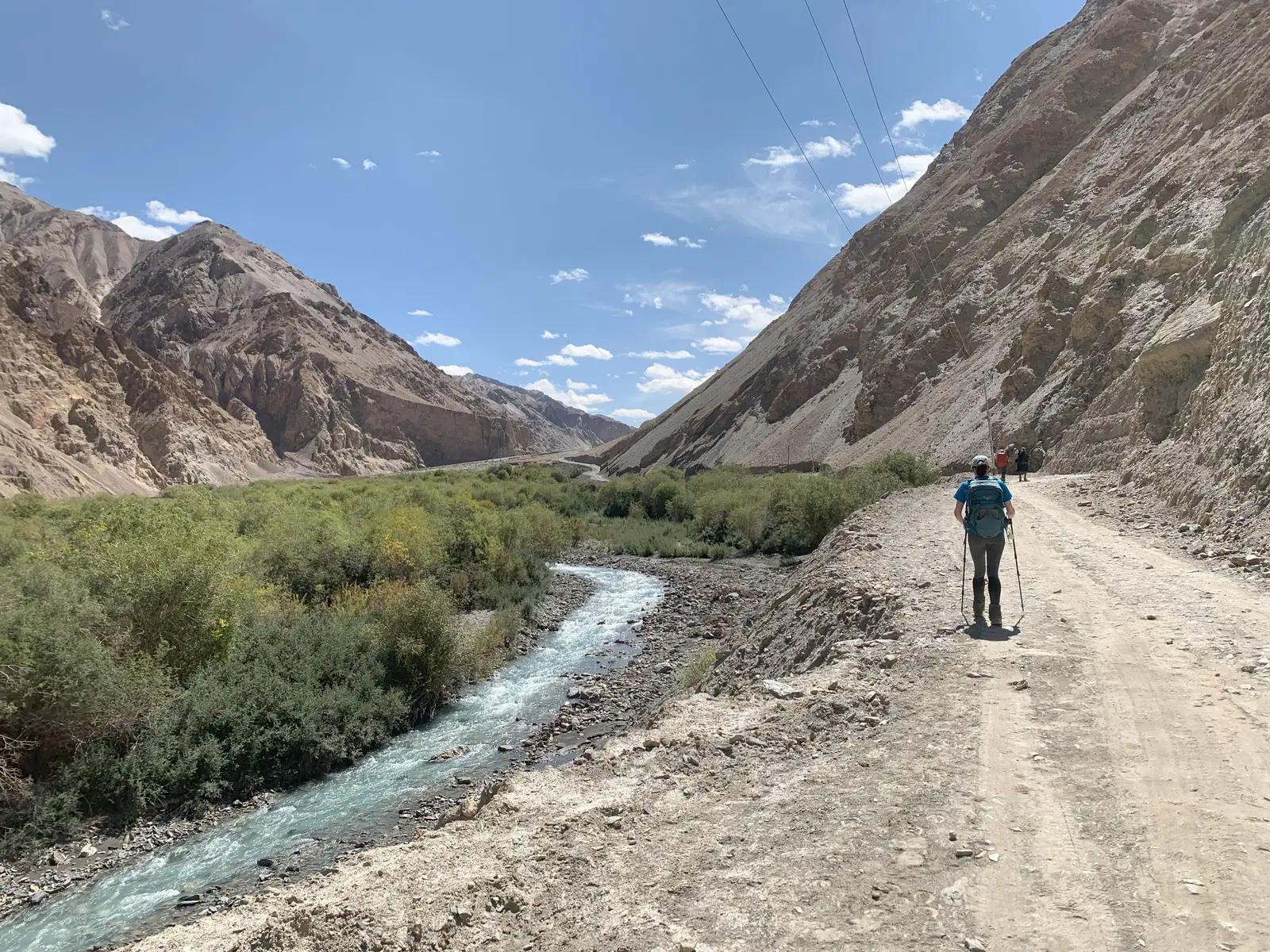
- The Vibe: A "Dry High." Unlike the green, wet treks of Himachal or Kashmir, this is a journey through a high-altitude cold desert. You walk through barren, multi-colored mountains, cross freezing glacial rivers, and sleep in parachute tents or traditional Ladakhi homestays. It is a cultural immersion into Buddhism and high-altitude living.
- Difficulty: Moderate to Difficult. The challenge is not the terrain (which is mostly valley floor), but the altitude. You rarely dip below 11,000 ft, and the pass crossing is at 17,060 ft.
- Duration & Variants: 6-8 Days (Standard Itinerary). 78 km Total Distance.
- TrippinAI Recommended Slot: July to Mid-September. While the rest of India faces monsoons, Ladakh remains dry and sunny.
- The TrippinAI Rating: "At TrippinAI, we rate this trek a 7/10 on endurance. The daily distances are long (15-18 km), and the air is thin, but the unique ability to stay in 'Tea Houses' (homestays) lightens the load."
The Climb: What to Expect
The Reality Check: Markha Valley is a geological museum. The trek starts near Leh (Chilling/Skiu) and follows the Markha River upstream. The landscape is Stark—shades of purple, brown, and ochre dominate, broken only by the green oasis of barley fields near villages. You walk past Mani walls (stones inscribed with prayers) and ancient Chortens. The valley narrows and widens dramatically, forcing you to cross the river multiple times (waist-deep water is common). The climax is the climb to Kongmaru La (17,060 ft), where you are rewarded with a view of the Karakoram range and the massive Kang Yatse peak, before descending into the strangely colored gorges of Shang Sumdo.
Why It's Famous & What Trekkers Say
The Fame Check:
- The "Tea House" Experience: It is one of the few treks in India where you don't need a tent. You can hike from village to village (Skiu -> Markha -> Hankar), staying in local homes, drinking butter tea, and eating fresh Ladakhi food.
- The "Snow Leopard" Territory: The trek runs through Hemis National Park, the prime habitat of the Snow Leopard (though sightings in summer are rare, the Blue Sheep are common).
The Social Pulse:
- The Good (What Trekkers Love): The homestays. Interacting with Ladakhi families and seeing their sustainable lifestyle is rated higher than the scenery itself. The view of Kang Yatse II (a 6000m trekking peak) is a favorite photo op.
- The Bad (What Trekkers Hate): The dust and sun. The sun at this altitude is harsh (high UV), and the trail is dry and dusty. The river crossings in July can be freezing and swift, scaring many.
The Trail: Milestones & Route Map
The Route Breakdown:
- Chilling/Skiu: Start Point (11,000 ft). The Highlight: You cross the Zanskar River on a trolley bridge or the new steel bridge to enter the valley.
- Markha Village: Day 3 Camp (12,200 ft). The Highlight: The largest village in the valley. Visit the ruined fort and the monastery.
- Hankar: Day 4 Camp (13,100 ft). The Highlight: The view of Kang Yatse peak opens up here. The last village before the high meadows.
- Nimaling: High Camp (15,400 ft). The Highlight: A vast, windy plateau where shepherds graze yaks. It is incredibly beautiful but freezing cold at night.
- Kongmaru La: Summit Pass (17,060 ft).The Highlight: The highest point. Prayer flags flutter in the wind. The view of the Indus valley on the other side is dizzying.
- Shang Sumdo: End Point (12,000 ft). The Highlight: The descent through a narrow, colorful canyon made of purple and red rocks.
How to Reach (The Gateway Hubs)
The Navigation Breakdown:
- State/UT: Ladakh.
- Gateway Hub: Leh.
- Start Point: Skiu (Drive from Leh via Chilling).
- End Point: Shang Sumdo -> Drive to Leh.
- By Air: Fly to Kushok Bakula Rimpochee Airport (Leh).
The TrippinAI Verdict:
- Most Cost Efficient: Shared Taxi from Leh to Chilling/Skiu (~INR 500-700).
- Most Time Efficient: Private Taxi arranged by operator (~INR 4,000 per cab).
- Acclimatization Note: You MUST spend at least 2 days in Leh doing nothing before starting this trek. Flying from Delhi (1,000 ft) to Leh (11,500 ft) is a massive jump.
Total Budget & Hidden Costs
The Wallet Damage:
- TrippinAI Budget Rating: Mid-Range.
- Permits: Wildlife & Inner Line Fees. Required for Hemis National Park.
- Trek Package: Expect INR 18,000 - 25,000 per person (Full Service).
- Homestay Trek (DIY): If you carry your own pack and stay in homestays, you pay ~INR 1,500 - 2,000 per night (includes dinner, breakfast, and packed lunch). Total trek cost can be as low as INR 12,000.
Smart Spending Hacks:
- Hack #1: Go DIY with Homestays. You don't need a tent, food, or sleeping bag (homestays provide heavy blankets). Just carry a daypack with water and clothes. It’s 50% cheaper and supports locals directly.
- Hack #2: Refill Water. Don't buy plastic bottles. Every homestay has boiled/filtered water. Fill your hydration bladder for free or a nominal fee.
- "Use TrippinAI for more accurate and personalized information on costs."
Food & Local Legends
Context:
- The Flavor: Homestays serve Thukpa (noodle soup), Skyu (pasta stew), and unlimited Butter Tea. At Nimaling, try the fresh Yak Cheese/Yoghurt.
- Local Insight: Locals believe the mountains are inhabited by Lhas (spirits). On Kongmaru La, you must add a stone to the cairn (pile of rocks) and shout "Ki Ki So So Lha Gyalo" (Victory to the Gods) to ensure safe passage.
Seasonality, Safety & Health
Best Time to Visit:
- July-August: Peak season. Warm days, cool nights. The river crossings are highest (meltwater).
- September: The river levels drop, making crossings easier. The barley fields turn golden.
- Avoid: Winter (Nov-May). Temperatures drop to -30°C. The trail is blocked by snow.
Traveler Safety Verdict:
- For Solo Travelers: High Safety. The homestay system makes it very safe. The trail is well-marked and busy in season.
- For Female Travelers: High Safety. Ladakhi culture is very respectful. Homestays are family-run.
- For Beginners: Caution. Do not underestimate the altitude. If you get AMS at Nimaling (15,400 ft), evacuation is difficult.
Risks & Actionable Mitigation:
- AMS (Acute Mountain Sickness): The most common reason for failure. Mitigation: Diamox. Start a course (after consulting a doctor) before flying to Leh. Drink 3-4 liters of water daily.
- Sunburn: The UV index is extreme. Mitigation: Sunscreen SPF 50+. Apply every 2 hours. Wear a hat and sunglasses even on cloudy days.
- "Check TrippinAI for real-time weather updates."
Getting Trek-Ready
Preparation Tips:
- River Sandals: You will walk through water. Carry Crocs or sandals that don't slip. Drying boots is impossible.
- Dust Protection: The trail is dusty. Carry a Buff to cover your nose and mouth to prevent "Khumbu Cough."
- Cash: No ATMs after Leh. Carry small denominations to pay homestays.
Expedition Essentials
- Footwear: Trekking Boots + River Crossing Sandals.
- The "Hero" Item: Lip Balm with SPF. Lips crack and bleed easily in the dry air.
- Clothing: Windcheater. The wind at Nimaling and the pass cuts through layers.
FAQ: Trekker's Most Asked Questions
Q: Do I need a sleeping bag for homestays? A: No. Homestays provide clean bedding and heavy blankets. However, carrying a hygienic sleeping liner is a good idea. (At Nimaling, you stay in fixed tents which also provide bedding).
Q: Is there mobile network? A: No. Signal dies near Chilling. You might catch a whiff of BSNL at high passes, but assume zero connectivity for 6 days.
Q: Can I skip the river crossings? A: In low water (Sept), maybe rock hopping works. In July, No. You have to wade through. Bridges are often washed away.
Planning Markha Valley? The river level changes by the hour. Morning crossings are safe; evening crossings can be deadly. Static blogs won't tell you the current flow. TrippinAI provides real-time river level updates from local guides. [Check River Status Now.]
Recommended for You
Namdapha Rainforest Trek Guide: The "Amazon of India" & The Four Cat Realm
Japfu Peak Trek Guide: The "Rhododendron Giant" & Valley Watchtower