Sar Pass Trek Guide: The "Snow Slide" Graduation for Beginners
📍The Mighty Himalayas (North India)
The Summit Summary
- Location: Himachal Pradesh (Parvati Valley, Kullu District).
- The Vibe: A "Live Geography Lesson." This trek is famous for its perfect daily transitions: Day 1 is thick pine forest, Day 2 is open meadows, Day 3 is steep rocky ridges, and Day 4 is a pure snow world. It feels like a curated tour of every Himalayan terrain type.
- Difficulty:Moderate. It is widely considered the perfect "Step Up" trek for those who have done easy treks (like Triund/Kheerganga) and want to experience high altitude without technical mountaineering.
- Duration & Variants: 5-6 Days (Standard Itinerary).48 km Total Distance.
- TrippinAI Recommended Slot: May to June. This is the only window when the pass is accessible and covered in enough snow to allow the famous slide.
- The TrippinAI Rating: "At TrippinAI, we rate this trek a 5/10 on endurance (due to the steep ascent to Nagaru and the windy, exposed ridge walk)."
The Climb: What to Expect
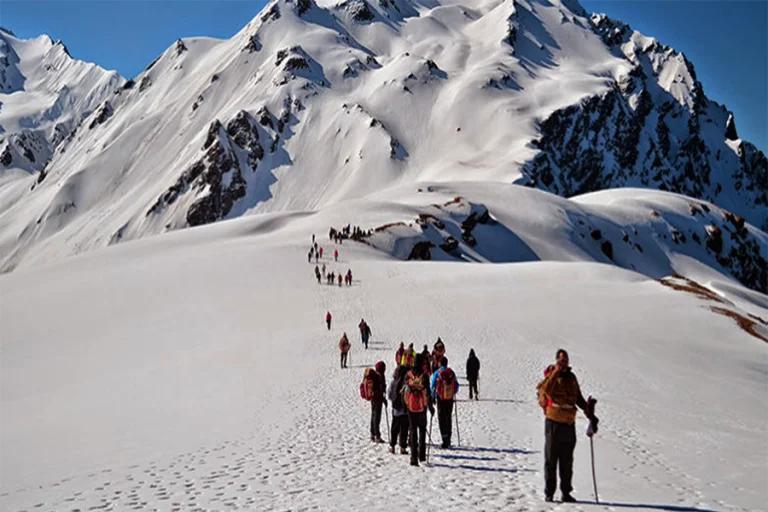
The Reality Check: The Sar Pass trek starts deceptively gently in the hippie-hub of Kasol, winding through the ancient village of Grahan where wooden homes smell of cedar and woodsmoke. As you climb to Min Thach, the forest drops away, revealing a chaotic skyline of jagged peaks. The challenge peaks at Nagaru—the coldest, windiest campsite perched on a cliff edge where tents flap violently all night. The summit push is a sensory overload: a frozen lake ("Sar" means lake in local dialect) hidden under ice, followed by the pass crossing at 13,800 ft. But the real hero is the descent—a thrilling, gravity-defying slide down snow slopes that drops you into the lush, flower-filled meadows of Biskeri Thach.
Why It's Famous & What Trekkers Say
The Fame Check:
- The "Longest Slide": Sar Pass is legendary for its snow slides. In a good season, trekkers can slide for nearly 1 km continuously from the pass down towards the valley. It’s the closest thing to a natural water park slide, but on snow.
- The "Changing Scenery": It is often cited as the trek with the most diverse landscape per kilometer in the Parvati Valley.
The Social Pulse:
- The Good (What Trekkers Love): The slide! It is the highlight of every review. The campsite at Biskeri Thach is often voted as one of the prettiest in Himachal.
- The Bad (What Trekkers Hate): The cold at Nagaru. Reviews frequently warn about freezing winds and lack of sleep at the base camp. The steep descent to Barshaini on the last day is hard on the knees.
The Trail: Milestones & Route Map
The Route Breakdown:
- Kasol: Start Point (5,180 ft). The Highlight: The trek starts from the center of Kasol, moving away from the cafes into the Grahan Nallah valley.
- Grahan Village: Day 1 Camp (7,700 ft). The Highlight: A 500-year-old village where mobile networks die and traditional Himachali culture thrives. Alcohol is strictly banned here.
- Min Thach: Day 2 Camp (11,200 ft). The Highlight: The "Meadow of Minerals." Locals say the soil here is rich in medicinal herbs.
- Nagaru: Base Camp (12,500 ft). The Highlight: The "Windy Cliff." You camp on a narrow ridge with the lights of the Parvati Valley visible far below.
- Sar Pass: Summit Day (13,800 ft). The Highlight: The frozen lake (Sar) and the adrenaline-pumping slide down.
- Biskeri Thach: Descent Camp (11,000 ft). The Highlight: A lush green meadow filled with wildflowers, starkly different from the snow you just left.
- Barshaini: End Point. The Highlight: The roadhead. You can take a bus/taxi back to Kasol from here.
How to Reach (The Gateway Hubs)
The Navigation Breakdown:
- State: Himachal Pradesh.
- Gateway Hub: Delhi / Chandigarh.
- Base Hub: Kasol.
- Start Point: Kasol Market.
- End Point: Barshaini (15 km from Kasol).
- By Air: Fly to Bhuntar Airport (Kullu).
- By Bus: Volvo from Delhi to Kasol/Bhuntar (Overnight).
The TrippinAI Verdict:
- Most Cost Efficient: Volvo Bus to Bhuntar (~INR 1,000). Local Bus from Bhuntar to Kasol (~INR 50).
- Most Time Efficient: Fly to Bhuntar + Taxi to Kasol (1 hour drive).
- Most Popular: Direct Volvo to Kasol is the standard choice.
Total Budget & Hidden Costs
The Wallet Damage:
- TrippinAI Budget Rating: Budget-Friendly.
- Permits: No Major Permit Fees.
- Trek Package: Expect INR 7,000 - 10,000 per person. It is one of the most affordable 5-day treks in India.
- Transport: Budget extra INR 200 for the bus/taxi from Barshaini back to Kasol.
Smart Spending Hacks:
- Hack #1: Eat at Grahan. Instead of carrying heavy packed lunches for Day 1, eat at a homestay in Grahan village. The food is fresh, organic, and cheap (INR 150/meal).
- Hack #2: Rent Gear in Kasol. Kasol has dozens of rental shops. You can rent a down jacket for INR 100/day instead of buying one for INR 5,000.Save INR 4,500.
- "Use TrippinAI for more accurate and personalized information on costs."
Food & Local Legends
Context:
- The Flavor: In Kasol, try the Evergreen Cafe for Israeli food or Mama Cafe for momos. In Grahan, ask for Rhododendron syrup (Buransh) mixed with water.
- Local Insight: The villagers of Grahan are said to be descendants of a high-caste family that was banished from the main valley centuries ago. They maintain strict purity laws (no alcohol, no meat in certain areas).
Seasonality, Safety & Health
Best Time to Visit:
- May to June: The only window. The snow is firm enough to walk on but soft enough to slide.
- Avoid: July onwards. The snow melts, turning the slide into a dangerous rocky slope. Winter is impossible as the pass is blocked.
Traveler Safety Verdict:
- For Solo Travelers: High Safety. YHAI (Youth Hostels Association of India) runs massive batches here. Even if you go solo, you will be surrounded by hundreds of trekkers.
- For Female Travelers: High Safety. One of the safest treks in India due to the high volume of organized groups.
- For Beginners: Recommended. It pushes your limits (especially at Nagaru) but is technically straightforward.
Risks & Actionable Mitigation:
- The Slide: It looks fun but can be dangerous if you lose control. Mitigation: Elbows In. Keep your elbows tucked in to brake. Do not slide head-first. Follow the guide's track.
- Wind Chill at Nagaru: Nagaru is notoriously cold and windy. Mitigation: Layer Up Immediately. As soon as you reach camp, put on your down jacket. Do not wait until you feel cold.
- "Check TrippinAI for real-time weather updates."
Getting Trek-Ready
Preparation Tips:
- Cardio: The climb to Nagaru is steep and at altitude. Run 5 km, 3 times a week.
- Gloves: Carry Waterproof Gloves. Woolen gloves will get wet during the snow slide and freeze your fingers.
- Sun Protection: The reflection from the snow at the pass is blinding. Carry UV Sunglasses.
Expedition Essentials
- Footwear: Trekking Boots with high ankle support (to prevent snow entry).
- The "Hero" Item: Polythene Bag/Poncho. You might need to sit on something waterproof while sliding if you don't have waterproof pants.
- Clothing: 3 Layers. Thermal, Fleece, Waterproof Jacket.
FAQ: Trekker's Most Asked Questions
Q: Is it safe to slide? A:Yes, if done under supervision. The slope is long but ends in a flat snowfield, so you naturally slow down. Guides usually station themselves at the bottom to catch you.
Q: Is there mobile network? A: Signal dies after Grahan village. You will be off-grid for 3-4 days until you reach Barshaini.
Q: Can I do this trek without a guide? A:No. The route from Nagaru to Biskeri over the pass is not marked and involves crossing snowfields. Navigation in fog is impossible without a guide.
Planning Sar Pass? The snow conditions for the slide change weekly in May. Static blogs can't tell you if the slide is open or icy. TrippinAI provides real-time snow reports and route updates. [Check Snow Status Now.]
Recommended for You
Namdapha Rainforest Trek Guide: The "Amazon of India" & The Four Cat Realm
Japfu Peak Trek Guide: The "Rhododendron Giant" & Valley Watchtower